3 waterfalls
on Greenland Creek
in
Panthertown
Click on any of the images on this page for full size/full resolution pic.
Panthertown is located within the Nantahala National Forest in Jackson County, North Carolina. Comprised of over 10,000 acres, Panthertown offers a wide variety of terrain, including flat, high elevation valleys, two monoliths rising out of those valleys, over a dozen waterfalls, and numerous creeks and rivers.
This trip report covers the three uppermost waterfalls on Greenland Creek: Greenland Creek Falls, Halfway Falls, and Carlton Falls, and provides a way to do a loop hike, rather than an out and back type of hike.
The first couple times I hiked to these falls, I did it as the latter type of hike ... out and back. But I got to looking at the current Kornegay map of Panthertown, and noticed that there was a "dotted line trail" that comes down from Hogback Mountain's crest to Greenland Creek, upstream from Carlton Falls, and that by following that trail up to Hogback, I could pick up another "dotted line trail" that followed Hogback's crest west for a mile or two, and then drop off the mountain to the north, intersecting with Mac's Gap trail.
Those of you familiar with the Kornegay map, know that there are two kinds of notation designating trails in Panthertown: dashed lines and dotted lines. The dashed line trails are clearly marked, often blazed, and easy to follow.
The dotted line trails are almost never marked or signed, and sometimes are not even present or able to be found.

Section of Burt Kornegay's map showing my proposed loop
I was intrigued about the aspect of making a loop hike out of a trip to these waterfalls, and eager to discover whether or not any of these "dotted line trails" were actually present, and if so, how clear and/or how easy to find and follow they were.
I figured that a counter-clockwise direction of this loop would make for the easiest route finding. I suspected that if any trails were least likely to be present, it would be in the section connecting Hogback's ridge with the Greenland Creek trail. In fact, the map shows that these two do NOT connect. So if there was any bushwhacking to do, I figured bushwhacking down from Hogback and finding Greenland Creek would be easier than the other way around.
What I found was that really EITHER direction will work (there are pretty clear trails the whole way), but that there are two turns that will be easy to miss, one if doing the loop clockwise, and another if doing the loop counterclockwise.
This trip report will present the counter-clockwise direction.
NOTE: Although this entire loop follows pretty much clear trails the entire way, none except Greenland Creek and Mac's Gap are labeled. You will need to be able to navigate via landmarks, distance traveled, and compass. So, this loop should only be attempted by folks comfortable navigating without assistance from trail signs or blazes. Panthertown has many, many unlabeled, unblazed trails, and this loop goes along several of them. You will come upon several intersections and branching trails that have no signage whatsoever, and you'll need the appropriate skills to note these intersections and know which way to head.
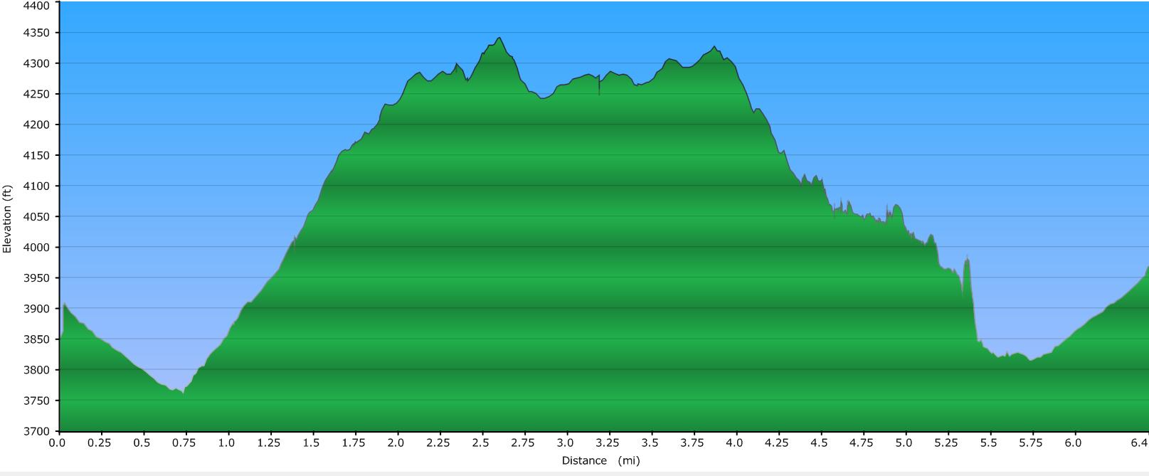
Elevation Profile
Click for larger image
Click here for a larger map
GPX data for download: GPS track for hike to Greenland Creek Loop Hike. *.gdb format for Garmin users, as well as *.gpx format included.
DIRECTIONS
The hike begins at the Cold Mountain trailhead in Panthertown. If coming from the east (Brevard/Asheville), follow US64 west to Hwy 281 North. Turn right onto Hwy 281, and in 0.8 mile, turn left onto Cold Mountain Road. A fire station is on your right at this turn.
Cold Mountain road will twist and turn as it makes its way along the north shore of Toxaway Lake. At 5.7 miles, the road will make a 90 degree left turn and become gravel. Straight ahead of you is a private community called Canaan Land. Turn left following the gravel road, and in another 600 feet, turn right following signs for Panthertown. Straight ahead of you is a road into another private community.
Once you make this final right turn, you are at the Cold Mountain Trailhead for Panthertown, and parking is where ever you can find a spot along the side of the road. The trail begins at the end closest to the private community end of the parking area (note that several other trails begin at the farther end of this parking area). The initial trailhead is labeled with a sign for Greenland Creek Falls.
Begin by heading up the wide, clear Greenland Creek trail. After a short distance, you'll pass through the power company right of way that cuts through all of Panthertown.
Follow this trail for about 3/4 mile, until you get to a wide sandy area. Greenland Creek will be immediately to your right, and you'll see a trail sign for Mac's Gap Trail that heads across the creek. Turn here, onto Mac's Gap Trail.
There is no bridge across the creek at this point, but just upstream a little, you'll find a place to rock hop. You can usually stay dry crossing here, if the water isn't up excessively.
Once across the stream, follow Mac's Gap trail for about 3/4 mile, until you come to an intersection of several trails.
The Beginning of the Unmarked Trail Section
At this intersection, Mac's Gap Trail (labeled) will continue to the right. Big Green trail (labeled) will continue straight ahead. And an unlabeled, wide forest trail will bear off to the left.
This is the trail you want to pick up.
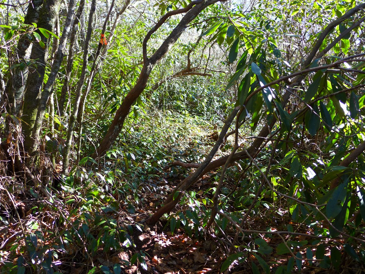
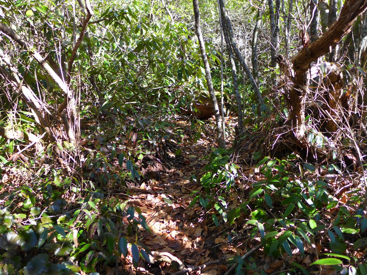
Once you've made the left turn onto this unmarked trail, it will bear generally in a southward direction, heading steadily uphill towards Hogback's crest. The trail remains wide and easy to follow the entire way. I did this hike in early winter and found the trail very clear; I suspect that in summer time this might have a lot of scrubby undergrowth and briars you might have to fight your way through.
As you gain elevation, you get some great views. First, off to the north-northeast, you see Cold Mountain (the Panthertown one), with its rocky cliffs clearly visible.
Further along, you see the very distinctive pyramid shape of Little Hogback Mountain straight ahead of you.
1.2 miles from your turn off of Mac's Gap trail, you come to a gate. This signifies you are close to Hogback's crest, and will be coming to the next turn you have to find.
The next unmarked set of trails
About 250 feet beyond the gate, the old forest road you're following continues straight ahead, with another old forest road bearing to the left (east).
Take the one heading to the left.
For the next 1.5 miles, you'll be heading mainly in a easterly direction, with the forest road you're following winding in and out of some shallow coves, and crossing 3 small tributaries. The ridge of Hogback marks the boundary between Panthertown and private property to the south, and at one point, you catch a glimpse of the rooftop of a house off to your right.
At 1.5 miles from where you turned onto this unlabeled forest road, it makes a sharp, almost 180 degree turn to the right.
Just prior to this turn, you'll notice a very faint path angling off to the left. This is the turn that will be very easy to miss if you're not watching for it. I initially thought it was just an animal trail.
However, once you start following this trail, it becomes a much clearer trail, that drops down off Hogback's ridgeline, and first heads through a section of thick galax, and then thick dog hobble before heading into dense mountain laurel.
About 0.3 mile after you make the turn off the main Hogback trail, you come to Greenland Creek.
At this point the creek is almost horizontal, and the water flow seems almost motionless. I did the hike during a fairly dry period, and the creek was at least 8" deep. A few folks must hike this section, because someone had piled up some rocks to create a way to rock hop across the creek, but they're awfully wiggly rocks!!
Another Easy to Miss Turn
Once across the creek, the trail continues on the other side through thick mountain laurel. 400-500 feet from the creek crossing you come to a "T" at the (unlabeled) Greenland Creek Trail. This is the turn that would be very easy to miss if you are doing this loop in the other direction (clockwise). This trail is very faint when compared with the wider Greenland Creek Trail. The day I did it, it was marked with an orange ribbon.
If you're doing this in the clockwise direction and hit the powerline right of way, you've gone 0.1 to 0.2 mile too far.
(Above) Turn to look for if doing the loop clockwise
Note the orange ribbon in the upper left of photo
(Below) The wider, clearer, Greenland Creek Trail heads straight
The Waterfalls
Going in the counterclockwise direction for this loop, you'll turn left at this intersection, and quickly come right up to Greenland Creek, at the very beginning of its descent down Carlton Falls.

Very top of Carlton Falls
A little further down, you'll come to the "bowl" area of these falls.
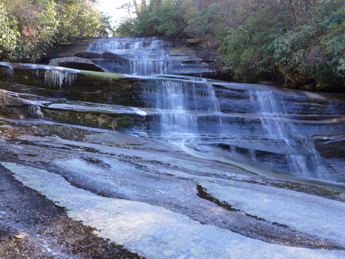
Top of Carlton Falls, just above the "bowl" area
And further down still, you'll come to the base of Carlton Falls:
Carlton Falls, from the base
Note that in this section, the trail you're following, while fairly easy to see and follow, is still quite "iffy" in places. It does not become a wide, easy to follow trail until you get past Greenland Creek Falls. If you find yourself heading uphill, away from the stream, and/or get into the electric line right of way, you've gotten off the trail. (Been there, Done that!!)
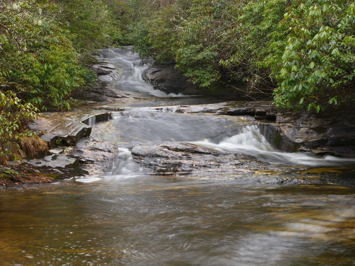
Once you've enjoyed Carlton Falls, continue on down Greenland Creek Trail. Note that in this next section, the trail will wind around in a big loop, leaving the main creek in order to cross a tributary, following it back down to where it joins Greenland. All together, it is about 0.4 mile from the base of Carlton to Halfway Falls. The trail will come out initially right at the base of the falls, but head downstream a little to get a better view.

Halfway Falls
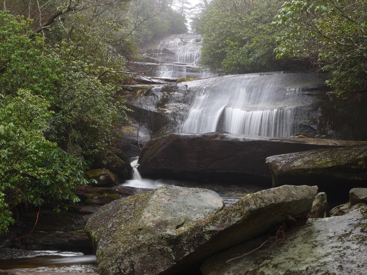
The largest of these three falls --- Greenland Creek Falls --- is another 0.4 mile downstream from Halfway Falls. The trail in this section is easier hiking than the section between Halfway and Carlton, with the exception of the final descent along the side of Greenland. This is as close to vertical as a "regular" trail will get; the good news is there are lots of trees and roots to hang on to. Nothing that a seasoned hiker can't navigate.
Just before you get to this steep descent, the trail comes RIGHT out at the edge of the creek, in what looks like a wide, flat area. The creek comes downstream, makes a 90 degree turn right about where the trail meets the stream, and then heads out into a wide, rocky, flat area. BE VERY CAUTIOUS HERE .... if you look past the flat area, you'll see the stream drop off the edge of the terrain. This is the VERY TOP of Greenland Falls ... a fall here would be fatal.
Just upstream from the top of Greenland Creek Falls
Make your way down the above mentioned super steep area that brings you to the base of Greenland Creek Falls. Here you will find lots of boulders and rocks to make your way out onto into the stream, allowing you to enjoy this massive waterfall.

Greenland Creek Falls
From here, it is just about one mile of easy walking back to the trailhead. Follow Greenland Creek trail downstream (note that immediately after you leave the stream, the trail makes its way through more boulders along the "path". You aren't following a trail as much as you are following a well worn footpath around and over these boulders.
Soon enough, you make your way past the boulders, onto a very clear path. In 0.3 mile from Greenland's base, you'll come to the intersection with Mac's Gap trail, where you crossed the creek at the beginning of your hike. Remain on Greenland Creek for another 3/4 mile, passing through the electric line right of way, and back to the trailhead.
More photos in my SmugMug gallery.